Condition:New
Type:Logic ICs
Model:BH4TDV
section - professional APRS double stage platform
The handset itself has built-in dual-mode Bluetooth. Selected external Bluetooth can be plugged into the PC. It can be connected with the built-in Bluetooth, wireless connection, wireless settings or PC communication.
The firmware version 20190212 C has been brushed to support dynamic navigation
When the dynamic navigation function is turned on, the distance and orientation between the rescuer and the rescuer will be refreshed every time a beacon is received.
When the search and rescue team is moving, it will refresh the distance and orientation of the rescuers in real time.
Hiking, search and rescue, patrol, exploration, event support, helicopter aerial photography flight measurement and control.
Mountains, deserts, oceans, lakes, air...
Before asking a question, say half a sentence:
Professional Platform, I would like to ask the professional points:)
Question: How far is the platform?
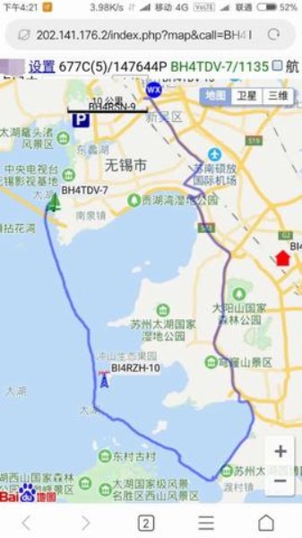
Answer: Urban environment 1-3KM, open area lake 1-8KM, standing on the space station, the whole of China
Question: Can you communicate with other brand handsets or platforms?
Answer: 1. As long as the frequency is the same, voice can communicate in a certain range.
2. Locate the same machine with APRS function
Question: Is it waterproof?
Answer: Simple waterproof, can't throw in the water.
Question: Is there an advanced waterproof machine?
Answer: Yes, get your purse ready, import YAESU 2DR and so on.
Q: How much power?
Answer: 5W
Question: Which mobile apps are supported by Bluetooth in UV98 handset?
Answer: Android Liuyun, Ovi, LOCUS MAP, APRSdroid, etc.
Apple, without software support, Ovi can try it under Apple.
Q: How many hours can a single battery work continuously in the field?
Answer: Interval launch, 5-8 hours, depending on the strength of trial use.
Question: How effective is it?
Answer: Practice on your own, but also see the comments.
Q: What is the use of Bluetooth?
Answer: Not necessarily, plugged into the computer, used to set the parameters of the UV98 handset wireless through the computer, or with the computer.
Map software communication.
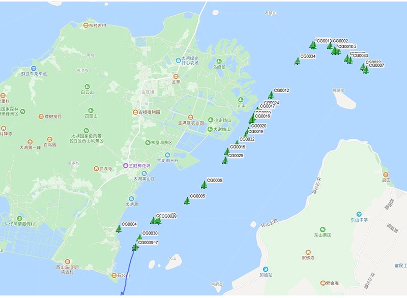
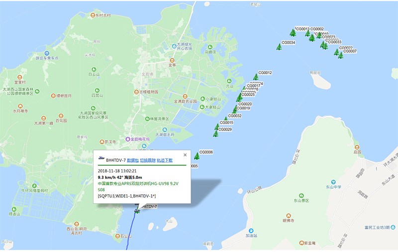
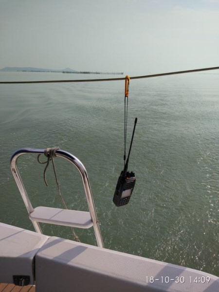
UV98 professional APRS dual-segment positioning console, using standard APRS digital coding, without the need for third-party networks andThe third partySoftware support can work directly and independently, and receive and receive positioning data directly through radio U/V signals. It is widely used in outdoor sports, event security, rescue and other occasions.
Host
SupportU/V dual-segment, A-segment receiving and receiving positioning data, B-segment voice calls.
5W, Fully Hand-set Frequency, Quick Frequency Adjustment
Supporting batteryUSB Direct Charging
Built in temperatureAuxiliary Sensors for Air Pressure and Voltage
Supporting User Autonomous Firmware Upgrade
APRS channel
Arbitrary setting of APRS channel and voice channel, A/B channel APRS, A/B channel voice
SupportCH A receives CHA, CHA receives CH B (differential), CHA receives, A + B receives.
SupportCH B receives CHB, CHB receives CH A (differential), CHB receives, A + B receives.
Supporting offline use, without network, directly positioning each other
Interface
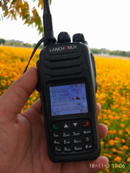
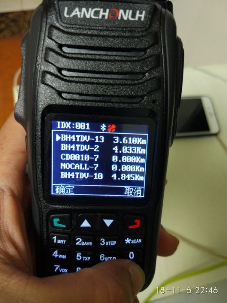
1.8 Inch color display screen, Chinese and English menu
Advanced supportGPS Interface, Beacon List Interface, Real-time Beacon Interface and Beacon Record Analysis Interface
APRS Track
Supporting Fixed StationFIXED, Sports SPORT, Two Site Models
Supporting integrityTRACK tracker, supportIntelligence, timing,PTTlinkage,queuebeacon
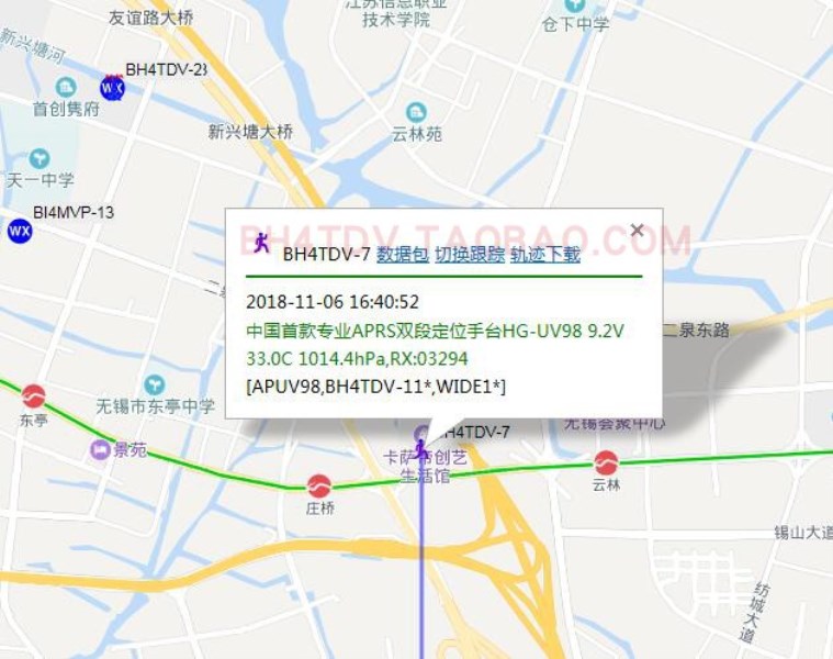
Support beacon additional information, mileage, satellite number, voltage, temperature, pressure, etc.
Support mileage calculation, cumulative mileage or automatic clearing0
Support for automatic iconsTRACK Intelligent Mode)
Bluetooth
Built in latest2.0+4.0 Dual-mode Bluetooth compatible with Android and Aple
Support Bluetooth OutputKISS hex, UI, GPWPL, KISS ASC, GS232B and other protocols
Support Bluetooth OutputGPS data (GPRMC + GPGGA) support hybrid output
Support BluetoothTwo-way Transparent Transmission of KISS Data
Supporting streaming clouds,APRSdroid,LOCUS, Ovi and other APPs
Support wireless Bluetooth setting parameters
APRS relay
Supporting integrityDIGI Relay Function, Support Self-defined Relay Name
Supporting Relay ChannelAB arbitrary forwarding
Support Relay Remote Open and Close Function
GPS/ Beidou
Built-in high performanceGPS Beidou GLONASS Multimode Hybrid Location Engine
APRS Algorithms
Built in premiumCMX Hardware Decomposition Algorithms
Built-in8-stage digital level regulator (both transmitter and receiver)
Data analysis
Built-in large capacity data storage,Storage, Viewing and Intelligent Sorting of 100 Beacons
Built-in high-level algorithmic, supporting rich data analysis functions
Computation of Supporting Heading, Normal North Position and Relative Motion Azimuth
SupportMeidenheid grid positioning system
SupportCALCULATION OF TRIANGULAR FUNCTIONS OF APRS DISTANCE, HORIZONTAL ANGLE AND Elevation
SupportAutomatic Tracking Control of G5500 Aircraft and Ships
Long-range
Telemetry control module supporting remote control peripheral sensor input and relay
Software
MatchingPC Setup Software (English) (Required. NET 4.0)
Supplementary information